Frequently Asked Questions
This measurement is carried out through global direct measurements using pyranometers in real-time. We placed dozens of pyranometers across the islands of Java, Madura, and Bali to provide accurate results.
Assessments or studies related to PV power plants always begin with collecting/analyzing irradiation data from a location. Generally, irradiation data is needed to determine the potential energy that can be generated by the plant from an area and perhaps compare it with others. In addition, this data can also be used for various other study purposes. Irradiation data is useful both for academics, research, government, and private parties engaged in the development/study of PV power plant.
We placed dozens of measurement devices all over Java, Madura, and Bali. But there are maybe times when you need irradiation data at a location where our devices are not on that exact location. Interpolation will be done by looking for the closest devices around your point at a certain radius. However, the position of our devices is spread evenly so that the interpolated data you will get is going to be quite accurate.
In the Search feature on the Map page, you can find the location you want by entering the coordinates (not the address) of the location you needed. The format used is DD format (Example: -6.2441, 106.8254). After entering the coordinates and pressing enter, the system will show your location and run the interpolation if needed.
You will get a Microsoft Excel Open XML Spreadsheet (XLSX) data file-type, which appear in the form of row and column of data if you open it in a number processing software such as Microsoft Excel.
Yes, you can use this data for any purpose. We strongly support academics to conduct research in the field of renewable energy. You can mention indonesiasolarmap.com in your study report so that you can engage your school or campus environment to research in the PV power plant field as well.
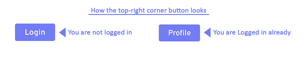
If you haven't registered or logged in, the Login button on the top right side of your screen will appear. If not, then the Profile button will appear.
 To register, press the Login button, then you will be directed to the Log In page. On this page, press the link that says “Not a User? Sign Up” and you will be directed to the registration page. You need to fill in your data and choose an access package.
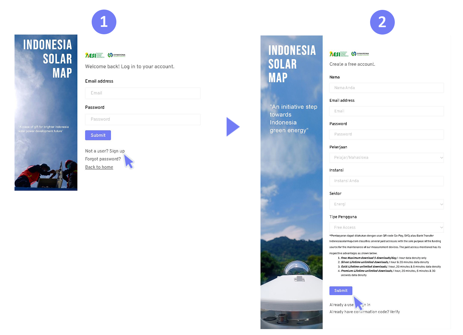 You can see an explanation of the access package types in Q&A Number 8. If the access package you choose is Free, you will immediately be directed to the Home page after the registration. If the access package you choose is the other, then you will be directed to the donation payment page to complete the registration process.
To register, press the Login button, then you will be directed to the Log In page. On this page, press the link that says “Not a User? Sign Up” and you will be directed to the registration page. You need to fill in your data and choose an access package.
You can see an explanation of the access package types in Q&A Number 8. If the access package you choose is Free, you will immediately be directed to the Home page after the registration. If the access package you choose is the other, then you will be directed to the donation payment page to complete the registration process.
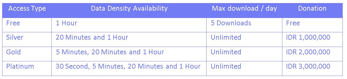
We provide 4 types of access, which are free, silver, gold, and platinum access. What 2022 distinguishes these four types of access is the type of availability of the data density when downloading data. This data density may be useful depending on the purpose for which you download this irradiated data.
 Before you can download, you must register and choose the type of access you want. You may upgrade your access type in the Profile menu after logging in.
Before you can download, you must register and choose the type of access you want. You may upgrade your access type in the Profile menu after logging in.
In Indonesiasolarmap.com there are two ways to do this, which are:
-
By using the download page, you only need to fill in the form section provided that contains details of the location you need. After completing the form, you can press the download button and acquire the data as a file.
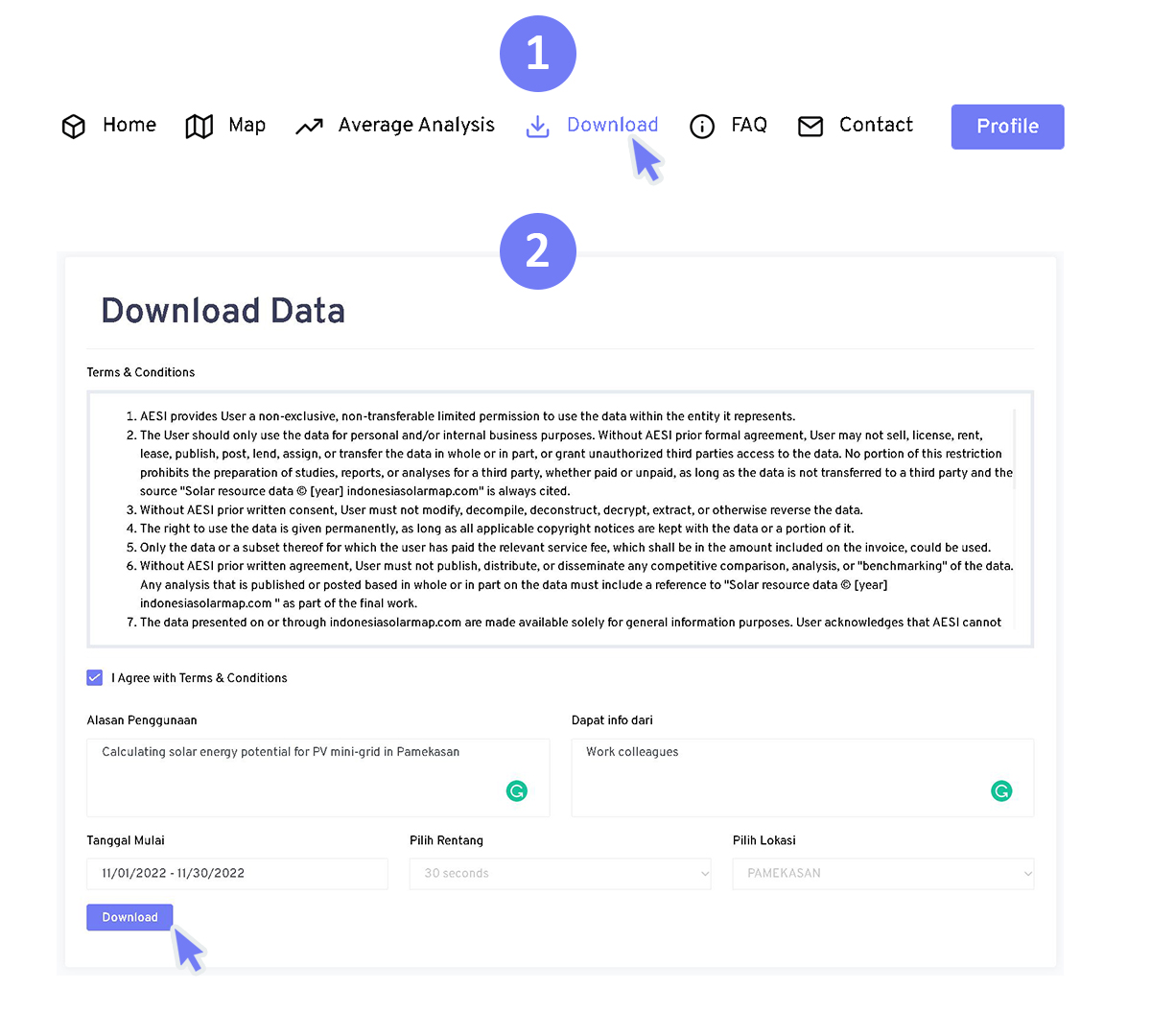 Please note that the type of data range available will depend on the type of data access you have.
-
By using the map page, the 2nd way to downloading irradiation data begins by selecting the location you want on the map. After that, on the right-side tab where various graphs and statistical data are displayed, you will find a download button.
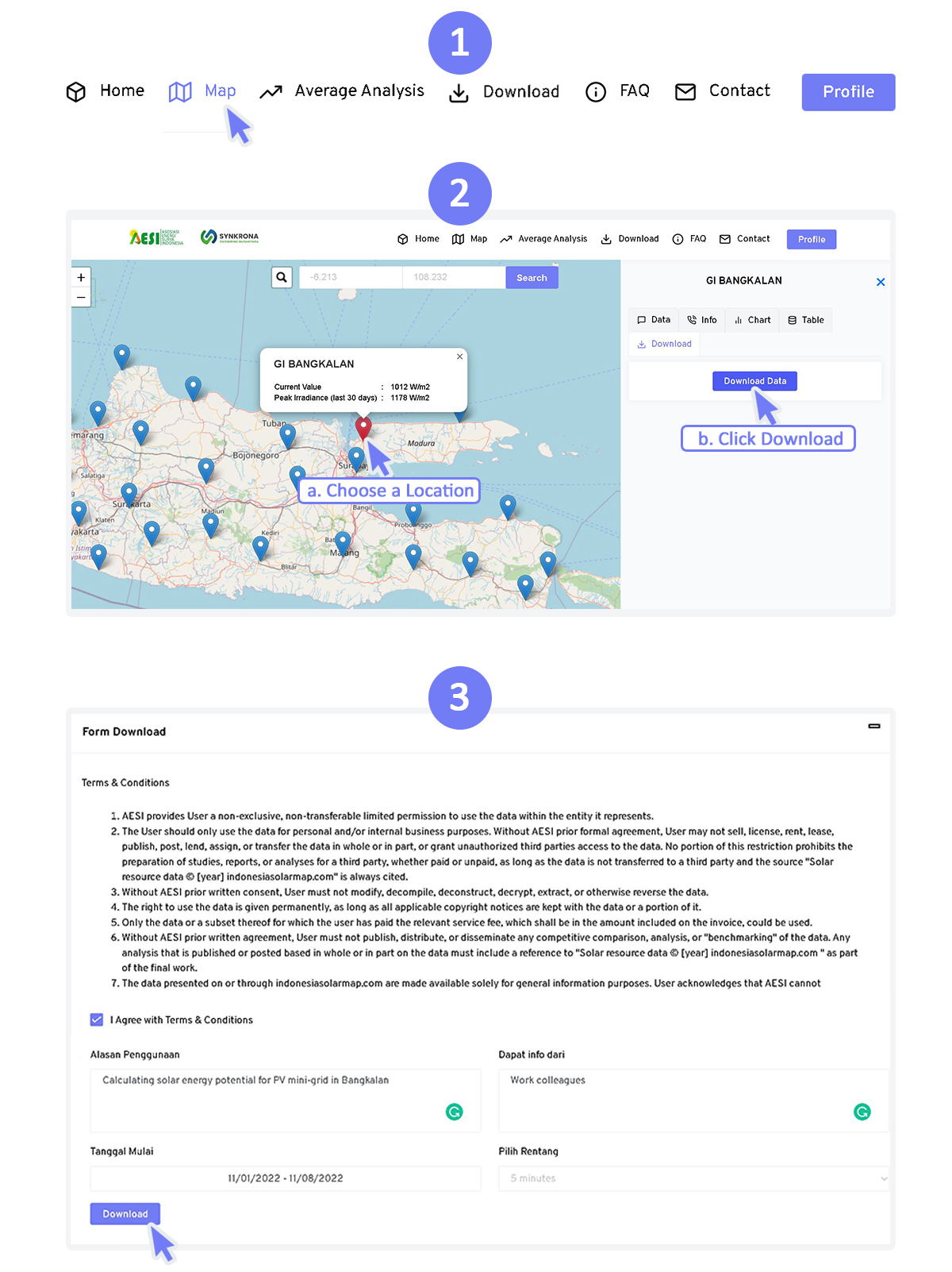 Press the download button then you will be forwarded to the download page. Here, you also need to fill out a form containing some information. However, the location column doesn't exist (locked) because the irradiation data will automatically be customized according to the location you choose on the map.
Yes, some data types require your donation to access. Please note again that the irradiation data provided by Indonesiasolarmap.com was obtained by placing dozens of instruments across Java and Bali. These instruments require operations and maintenance funds to ensure the measurement system works properly. Therefore, we hope that the donation system will provide future operational and maintenance financing support. The non-free user only needs to make this donation once to have an unlimited active period of the account.
We appreciate all users who contribute to the continuation of this program through the donation system. Even so, we still provide free data for you to use as an alternative option.
Apart from using the donation system, you also have the opportunity to participate directly through sponsorship. You can see our sponsorship scheme offering here:
Sponsorship Scheme Offer
We dedicate this data to Indonesia, this data is available to use for any purpose. Meanwhile, access classes that need to be obtained with donations are intended solely as a source of funds for operation and maintenance.
The method we use is real-time measurements at dozens of locations that were taken in 2021 & 2022 across Jawa, Madura, and Bali. This platform is the only one that does this in Indonesia recently. Most likely the platform you are referring to has a different data collection/calculation method or data retrieval date.